
N by NW
by Mike Crowe
Originally published in the Fishermen’s Voice in 2004.
Many others at fishermensvoice.com Archives.
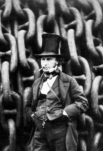
Isambard Kingdom Brunel (1806-59), engineer and designer of the first propeller-driven, iron-hulled steamship, the Great Britain, launched in 1843. The iron ship compounded the problem of shipboard metal throwing off compasses. Brunel was known for his big projects – ships, bridges, etc. It is not a coincidence that this photo finds him with giant chain links for a background. On it’s fifth transatlantic trip, the Great Britain left Liverpool for New York. Steaming along on a dark night it slammed into the Irish coast, a victim of its compass. Robert Howlett photo.
When English settlers at Popham Beach, Maine, threw in the towel or whatever was thrown back in 1608, the trip began with the building of a ship. After their first long winter, out of food, at odds with the native Americans and their leader dead, they decided to return to England. There was a shipwright among them, but, being the only European settlement, other than Jamestown, Virginia, in what is now the U.S., they were not going to buy the tools or the sawn lumber they needed. What they built was a 50' “pinnace,” the first ship built in America and which they named the Virginia.
But all these things were not the greatest problems they would find themselves facing. For they had little knowledge of the seas they would sail and, at best, not much of a compass to guide them. On clear nights they could have sailed by the stars, days by knowledge of prevailing winds and currents. But in a storm, all these things changed.
Before the advent of the compass, other navigational tools were used, such as knowledge of the winds, currents, and the seasonal patterns of various sea animals. Norsemen sometimes used birds by carrying them on board. When they thought they were close to land, a bird was released, if it flew away, it was followed toward land. If it returned, it was assumed they were not near land.
There is evidence that the Chinese discovered that lodestone was naturally magnetic and oriented itself in a north-south direction at least as early as 84 A.D. It could also be used to magnetize metal. But the early use of the compass in China was for practicing feng shui (the science of winds and waters), a system of arranging buildings, walls, streets, etc., that they believed most benefited the people using them. For the Chinese, south was the principal direction. The “magnetic” needle is mentioned in a Chinese text, dated 1040 A.D. It describes a magnetized metal fish that was floated in a bowl of water where the fish’s head pointed south. Travel to China, for the most part, was overland, until the sixteenth century, when western trading ships arrived. Those ships, by then, most likely had improved European versions of early Chinese magnetic compasses.
Marco Polo went overland to China with his father in 1271 and was believed to have brought back a compass; he may have, but others likely preceded him. Englishman Alexander Neckham wrote of a magnetic compass in 1187, and in fact, several Europeans have been credited with having invented the compass in the 1300s.
Reliance on the compass
could be more deficit
than asset.”
The earliest European compasses were a magnetic needle attached to a piece of straw floating in a bowl of water. Hovering over the bowl, a navigator waited for the needle to settle into pointing north. A vessel pitching in a seaway made this model of little use. Later versions included a wind rose printed on a thin piece of cardboard with a magnetic needle glued on, and both balanced on the point of a pin. This was pretty much what the compass remained until the late 18th century. It was more an aid to navigation along with the other means — celestial, winds, currents, etc. Nonetheless, the compass had a major impact on European commerce. Captains felt they could travel offshore and did. In the Mediterranean of the late 1200s, better navigation charts, a manual for sailing the Mediterranean Sea and the more common use of the compass led to a boom in trade. This expansion continued into the 1400s, when Europeans, including Columbus, sought to explore the world for markets and resources. The compass has been likened to the wheel in its importance. It was high tech for its time. But the compass Columbus used in 1492 was not much better than those of the 1200s and not much worse than those of the 1700s. The understanding of how the marine compass worked came many centuries and thousands of shipwrecks after being introduced.
The global positioning system is better understood by the average person today than the compass was understood by expert mariners of the 18th century. By that time, the compass rode in a gimbal that allowed it to remain level on a moving ship and was set on a permanent binnacle at the helm. Previously it had been kept in a box and brought out for use. Until the 19th century, the compass was simply a magnetized needle that aligned itself with the earth’s magnetic field. That part was well known, but it was not the whole story. Why the compass needle pointed less accurately at different places on the earth and in different vessels was not understood. Until deviation and variation were understood enough to develop a means of adjusting the compass with magnets, and accurate charts were made, reliance on the compass could be more deficit than asset.
All this did not keep mariners from sailing by it, creating long lists of ships that confidently followed the compass needle onto the rocks. Columbus was skilled in the simple method of dead reckoning to locate his position. He used time traveled with an hour glass and speed with a log tossed over the side. From one known position to another along a compass course he could approximate his position. Others were not so skilled or lucky.
One of them was British Admiral Cloudesley Shovall, who, in October, 1707, was returning from an assault on the French fleet in the Mediterranean. Believing his position to be just west of the English Channel, he ordered a course change, dismissing the contrary opinion of one of his captains. Before long, breakers were spotted and it became clear, as well as too late, that they were going onto the granite reefs at the Scilly Islands, well south of the channel. Four of the five Royal Navy ships were pounded into splinters. 1900 men were lost, with the exception of Shovell, who washed up on shore. Decades later, a woman’s deathbed confession revealed that he had been killed on the beach for his diamond rings.
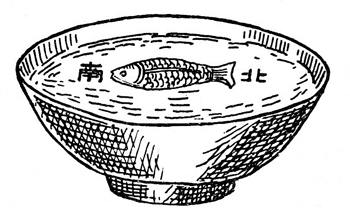
At least as early as 1040 A.D. a compass made with a magnetized metal fish floating in a bowl of water was used to indicate south. It was used to align construction projects. Overland traders are believed to have taken the idea to Europe around 1100 A.D., where it evolved into the marine compass.
While this disaster was the result of inaccurate charts and shoddy compasses, it resulted in the British government creating a Board of Longitude, in 1714. Columbus had “sailed the latitude,” in a straight line across the sea. This could be done by observing the sun at noon or by guide stars. Longitude, however, is calculated from the difference between high noon on board ship and the time at another point of known longitude traveled from. The government offered a prize to anyone discovering a practical method of determining a ship’s longitude. The 20,000 pound sterling prize would be equal to several million dollars today.
The difficulty of the problem can be ironically illustrated by the lack of understanding of even how the compass operated. Some suggestions considered for adjusting the compass magnetically were fairly cockamamie and illustrate how confounded they were by the force affecting the device. Determining longitude required knowing the time at sea and the time at the home port or at another known longitude. The hour difference between the two clocks is translated into distance, since the earth in 24 hours makes a 360 degree spin. One degree of longitude at the equator equals 68 miles, however, at the poles, one degree is nearly zero.
Proposals included
ships strung across
the ocean at 600-mile
intervals, firing cannon
to mark midnight.
Clocks at the time were operated by pendulums, which on a rocking deck at sea went helter-skelter. In general, clocks were inaccurate, but at sea, with temperature changes expanding and contracting metal parts and softening and stiffening the grease on moving metal parts, they were useless for navigation. Yorkshire clockmaker John Harrison obsessed over the problem and pretty much devoted his life to solving the problem and winning the prize — he did both.
In 1735, he presented his clock to the government. Two key solutions to the problem of building an accurate shipboard clock for determining longitude were in the use of wood parts and metal springs to keep the clock running. The wood he chose to carve the gears, etc., from was ligna vitae, an extremely tough and naturally oily wood. Metal springs replaced the pendulum. Harrison’s chronometer lost one second in a month, while the best watches of the day lost a minute in a day.
Over the years, competing longitude proposals included having ships strung across the ocean at 600-mile intervals, firing cannon to mark the midnight hour. The answer was sought in the sky which, for so long had been used as a guidance system for travelers. The use of solar and lunar eclipses, including the moons of Jupiter, were also proposed for setting the positions of these signal ships.
Until solar and lunar-stellar distances were calculated from the Greenwich meridian in 1767, sailors used any convenient meridian from which to state their position. The widespread use of the calculations at Greenwich, seven miles outside London, eventually established it as the base meridian and Greenwich Mean Time. The compass, it was later discovered, could be adjusted with magnets. Metal parts in and aboard wood ships created problems apart from the earth’s magnetic field. Each compass had to be adjusted for the ship it was on. One hundred years after the marine clock was invented, the marine compass was not quite there, when another curve ball was tossed onto the field.
Iron-hulled ships appeared around the mid-1800s, and things got really bizarre at the binnacle. Pounding in the rivets on iron ships while building them magnetized the hull. In some cases, the whole ship was a magnet. In addition to running aground, the iron ships soon got a reputation for sailing in circles off shore.
I.K. Brunel was the engineer and designer of the world’s first propeller-driven, iron-hulled steamship. The 3,500-ton Great Britain, after making a few trans-Atlantic trips, left Liverpool for New York on a dark night and soon rammed into the Irish coast. The well-constructed hull survived, along with all the passengers. Brunel was convinced the fault was with the compass and the British Admiralty which refused to recognize the inadequacy of their official compasses.
The wind rose or dry card in the magnetic compass was not stable.The launching, in 1877, of the British warship, Lightning, marked the useful end of the dry card compass. The Lightning, 85' long, with an 11' beam, was the first torpedo boat. It was steam-powered and did an unprecedented 18 knots. At that speed, the dry card was constantly moving. The year before, Ritchie’s Floating Compass was chosen by the U.S. Navy as its standard compass.
The floating compass was filled with a clear liquid, originally alcohol, which stabilized the motion of the card. A further improvement on the liquid compass was the dome-topped compass. These reduced error from the swirl of the liquid, and the card was also magnified by the curved glass.
In 1901, a German engineer proposed a new compass, the gyrocompass, using a directional gyroscope. In 1911, American inventor Dr. Elmer Sperry produced his own version, and, by 1920, the world’s navies were equipped with gyrocompasses. These pointed to true north and could also run an automatic helmsman. More recently, the global positioning system has become part of ship and small-boat navigation equipment. With all the electronic navigational equipment carried aboard large modern ships, the law still requires them to have a magnetic compass on board. When the electric power goes out, the magnetic compass is still operating.
Chapman’s Piloting and Seamanship says, “Always trust your compass.” A compass does not usually exhibit erroneous behavior. It is subject to natural laws, which totally govern its operation. For the small boatman its errors can be determined, reduced, and, once determined make the compass an exceedingly accurate instrument.
The compass started as a magnetic needle floating in a bowl of water and now has multiple magnetic needles floating in a jar of alcohol. The difference is the level of understanding of things outside the compass that affect it.