
Ocean Planners and Stakeholders Meet
Over Access and Decision Rights
by Mike Crowe
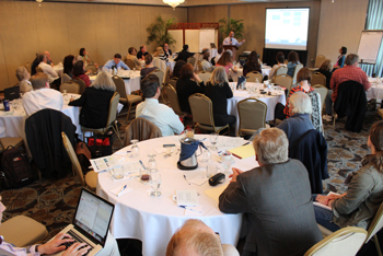
Federal and state agency representatives and stakeholders at the May 12, 2015, Northeast Regional Planning Body meeting. The RPB deadline for submitting a document of suggested guidelines for federal agencies is next year at this time. Agencies will have the option to use data in that document in overseeing and permitting industrial projects in the ocean. NOAA photo
SALEM, Mass., May 12 – The Northeast Regional Planning Body (NRPB) met here to focus on stakeholder discussions toward development of a Regional Ocean Policy (ROC), which will be a part of a National Ocean Policy. Ocean habitat and human use issues were the leading topics. This was the fifth of these meetings. The meetings are guided by Northeast Regional Ocean Committee (NROC), National Oceanic and Atmospheric Administration (NOAA) and institution employees, whose presentations set the stage for discussions among stakeholder attendees. Following presentations, small group discussions were noted and read to the whole group. Out of this, a consensus was reached on a few topics. Suggestions were then developed for how these topics may be embedded in a larger database for government agencies that oversee ocean uses such as energy, aquaculture, mining, fishing, shipping, etc. According to planners, it is hoped that developing a structure for what is anticipated to be greatly expanded industrial use of the nation’s slice of the oceans will be guided by this work.
Three established goals of the NRPB are healthy ocean and ecosystems; effective decision-making; and compatibility of uses. At the same time, according to Northeast Ocean Planning documents, whatever comes out of the RPB process must function within the existing regulatory framework. The Regional Planning Body (RPB) process will involve working with federal agencies to understand the use of collected data in existing decision-making, including permitting and leasing; use of the data in pre-application phases; and increased federal/state coordination under the Coastal Zone Management Act (CZMA).
“Ninety percent of
everyone who even
knows this is
happening is in this room.”
The approximately 50 people in attendance were many of the regular attendees over the last three years, less some of the scientists at the last RPB meeting in April. “Ninety percent of everyone who even knows this (The RPB process within Ocean Policy planning) is in this room”, said one NROC presenter. Not all at these meetings are equally informed about the economic and political context in which these ocean use changes will occur. The scale of the international interest in exploiting ocean resources suggests the potential magnitude may not be common knowledge.
Mapping the U.S. ocean areas has been a significant part of building the ocean-planning database over the last three years. The May 12 RPB presentation included some of the 1,500 ocean maps developed at Duke University; these maps describe human use patterns in fishing, transportation, marine life and recreation. During a mapping presentation, it was noted by John Weber, the federal lead in the RPB process, that lobster vessel monitoring system (VMS) data were not included, and yet were considered important to the New England database. Considering a vertical lines survey map, Weber said it is being used but more is needed, to better indicate how much lobster fishing is done in various areas.
Referring to the size of the final RPB document that might come out of the process, Beth Casoni, a Cape Cod, Mass., lobsterman, said the whale rope document was 2,000 pages. If the RPB document were five pages then the general public would have a chance of using it, she said. Casoni expressed her concerned about the tradeoff component by saying there were about 12,000 licensed lobstermen between Maine and New Jersey. If each of them fished about a square mile of ocean, then a lot of area from shore out several miles could be said to be under existing use, she said. “How will that use be impacted by relative economic tradeoff policies?” Casoni asked.
Stakeholder Patti Page of Gloucester, Mass., in considering the mapping and what it might mean for commercial fishing access, said, “It is important that the RPB vet any of these plans with people all along the (New England) coast.”
Marine transportation maps showed long-established tug routes, for example, which will remain while growth in traffic is expected at these places, along with new locations for other and larger container ships. Recreational use maps indicated similar data, but might be easier to change for other uses, stakeholders said. “The question,” said Weber, “is how to bring all this data to the existing regulatory framework.”
The regular reminder that the science, mapping data and stakeholder input being gathered will be going to the existing regulatory framework caused some stakeholders to express concern that their efforts might be tossed into a bureaucratic black hole, without so much as an echo for a response. The question was asked, How will regulatory agencies, given the information products created from the various data, use it to achieve the goal of effective decision-making? Richard Nelson said there should be stakeholders present in the nitty-gritty of the formal writing process, rather than relying on abbreviated notes or memory.
“The decision-making
process should not
be reactive.”
– Richard Nelson,
Friendship, Maine
Dense fishing patterns, transit paths and trawling, along the southern New England coast, were defined as hot spots of fishing activity. As such, stakeholders said, it was implied that they might therefore be considered off-limits for some forms of industrial development that would disrupt fish habitat. Oil and gas drilling and deep ocean mining would likely be disruptive activities, stakeholders said.
“This mapping system is just a zoning exercise,” said Gloucester, Mass., resident and water resources policy analyst Valerie Nelson. “Isolating areas and defining them as hot spots implies that anything that's done outside these hot spots is okay, implying that destructive extraction processes can operate anyplace else.” Nelson emphasized the importance of focusing on ocean health rather than the “same old” permitting process for industrial extraction.
The zoning component has come up at past meetings, but the word “zoning” is not directly used. At the April 8, 2015, RPB meeting, there was a discussion of spatial issues in ecosystem-based management. “How would fishing boundaries be defined and how would protected areas versus the larger general zones” be defined? asked Andrew Rosenberg, a director at the Union of Concerned Scientists and former director at the National Marine Fisheries Service. The implementation of zones in the face of new and greater human use implied trade-offs of who gets what, he said. Other stakeholders in Salem said the decision-making process around the trade-offs issue was fundamental to their interest in being involved in the ocean policy decision-making process.
Valerie Nelson, Priscilla Brooks, an economist at the Conservation Law Foundation, and Les Kaufman, a biologist at Boston University, called for a special RPB meeting focused on Ecosystem-Based Management (EBM) following the November 2014 RPB meeting. As a result, the problems around monetizing the ocean resource over maintaining ocean health were first brought up in detail at the April 8, 2015 RPB meeting. Ocean health is a stated goal of the National Ocean Policy; stakeholders said that goal should remain a central part of the discussion.
“It is good to have these maps and the data associated with them, but the question is, what will be done in the next year to advance ecosystem-based management? Could all the work that has been done to date result in a collaborative EBM effort?” asked Priscilla Brooks.
Citing marine biologist Anamarija Frankic and tribal leader Chuckie Green who were panelists at the April 8 meeting and had addressed the need to move forward in multiple directions to develop goals that would lead toward EBM ocean health and restoration, Valerie Nelson asked, “What is being done toward these goals?”
Some RPB members expressed concern about being left out of the decision-making process in the future. “The people involved in this (RPB) process want to be involved in the decision-making process that will take place beyond the data collection phase,” said Maine fisherman Richard Nelson. His concern was that the data will be collected, but then revert to the old Bureau of Oceans, Energy and Mining (BOEM) control over permitting and that decisions will continue to be made by this bureau. BOEM has gone through two title changes following controversy and charges of corruption in recent years.
“The success of an
Ocean Policy depends on
how stakeholders are
and remain involved.”
– Priscilla Brooks, CLF
“The decision-making process should not be reactive. Why should we have to wait for a corporation, like Statoil for example, to say they want to do this right here and we, the people, then have to react to that decision? We want to be proactive and be involved in the decision-making process beyond this current discussion stage. I would like to know what will be in place for New Englanders to be able to participate in the management of their part of the ocean,” said Richard Nelson.
According to informational documents, the request by the Obama Administration for the development of a National Ocean Policy was the result of international plans to greatly expand the use of the ocean and the ocean floor in the near future. Congress passed on funding the development of an ocean policy. Private funders stepped into the funding void. The Gordon & Betty Moore Foundation and the David Packard Foundation are primary funders of the RPB process. The Moore Foundation has funded the development of the catch shares programs. According to some New England observers, this monetization of the fisheries and ocean resources is part of a larger economic development and control strategy for the oceans, which includes large-scale fin-fish aquaculture, sand, gravel and deep ocean rare mineral mining and energy development. Wind and tidal energy projects are on the table, but some New England observers said big profits, infrastructure and Congressional clout of the oil and gas industry will dominate what kind if energy comes out of the Gulf of Maine. Participants in the RPB process said it is in that context that they expressed what they said is the need to establish a continued presence of something like voting rights for the public in how these resources will be managed. How that will be done is not clear, they said.
“The ocean plan is unfolding and while what it will be is unclear now, it is beginning to come into clearer relief,” said Priscilla Brooks. “The success of an Ocean Policy depends on how stakeholders are and remain involved in what we assume will be an ongoing process.” Brooks said the vast amount of data available offers a sense of what the ocean looks like and therefore how and what planners can do with that information, and how stakeholders on all side can take advantage of what the ocean offers while at the same time ensuring the ocean ecosystem survives. Brooks said she considered participation in developing an ocean policy a great and rare opportunity to effect positive change in an important area.
At the April 8 meeting, Rosenberg said, “If you only look at profit, then oil, gas, and tourism always win. Management needs to respond to public interests. Generally, management is responding to business interests.”
Upcoming NRPB Meetings
Semi-annual meeting-June 3&4, Mystic, Conn.
Meetings later in 2015 and into 2016 will be announced.
For more information, visit neoceanplanning.org.
More information and links to research, economics, science, politics and commentary on ocean development here.