
Sea Level Rise Hits Maine
by Laurie Schreiber
A major contributor to
sea level rise is ice melt.
Impacts of sea level rise are being experienced by Maine’s coastal communities, and they’re expected to worsen in the coming years.
That’s the word from the Gulf of Maine Research Institute of Portland, which sent Science Education Program Manager Gayle Bowness to Mount Desert Island in August to give a presentation on the topic.
Bowness asked the audience what impacts they were seeing locally. Answers included severe flooding, coastal erosion, damage to infrastructure like footpaths, storm surge that undermined the causeway leading onto MDI, submerged salt marshes, salt water intrusion into people’s wells, and the arrival of sea creatures from southern waters, including triggerfish, seahorses, sunfish, and jellyfish.
Hosted by A Climate to Thrive, a local nonprofit organization working to make MDI energy-independent by 2030, Bowness said the impacts of climate change are becoming increasingly visible in Maine and across the nation. That includes intense storms, unusual temperatures, ocean warming, and coastal flooding.
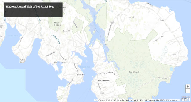
Top image shows Bass Harbor with 2015’s highest tide of 11.8 feet.
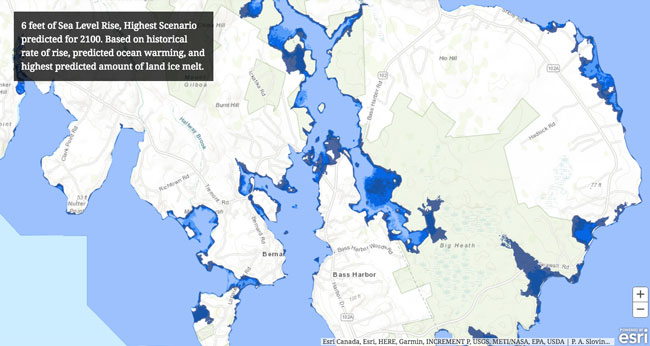
Bottom image shows Bass Harbor with 2015’s highest tide of 11.8 feet plus another 6 feet of sea level rise, projected as an extreme scenario for the year 2100. However, it’s difficult to say by how much and when the sea level will rise, said GMRI’s Gayle Bowness. “We may see more or less than 6 feet by 2100,” she said. “The Maine Geological Survey will be releasing map layers of 9 feet later this year.”
Courtesy GMRI, Maine Geological Survey, NOAA
Bowness said there are two primary drivers to sea level rise — warming waters and melting land ice. As the water warms, it expands, which causes sea levels to rise, she said. On top of that, melting glaciers turn ice that was trapped on land into water that drains to the ocean.
Trends show that, from 1990 forward, the rate of sea level has more than doubled from trends in the past, she said.
“It’s not something that’s going to happen to us later,” she said. “It’s something that has been happening already.”
Portland starts to flood at 11.8 feet. In 2018, Portland has already experienced tides of 12 feet or more 11 times, she said.
More fresh water coming from Greenland due to ice melt will have an impact, she said.
Adding one foot of sea level rise will mean an average of 100 flood events per year, she said.
Bowness presented National Oceanic and Atmospheric Administration charts that showed various sea level scenarios. The scenario with the lowest sea level rise, assuming that climate factors of the past will remain the same in the future, puts sea level rise at 8 inches by 2100.
But the rise is likely to be higher, she said.
We’ve never been in
coastal communities that
have roots in the ground
before. That’s the big deal.
A “mid low” scenario takes into account a major contributor to sea level rise – ocean warming and expansion due to warming – which puts sea level rise at 1.6 feet by 2100.
Currently, she said, a major contributor to sea level rise is ice melt. There are two types of ice in the ocean – land ice and sea ice. Sea ice, she said, is like ice cubes in a glass of water; when the ice melts, it doesn’t add volume. The same is true when an ice shelf calves off into the water, because it’s already displaced its volume of water, she said.
However, she said, melting sea ice allows land ice to have greater access to the water.
“So it’s specifically land ice melt that’s contributing to sea level rise,” she said.
The lowest amount of land ice melt predicted by 2100, in the “mid high” scenario, would result in nearly 4 feet of sea level rise. The highest amount predicted would result in about 6.5 feet of rise by 2100.
Most of that land ice is glacier in Antarctica and Greenland. Greenland is currently contributing almost twice the amount of land ice as Antarctica, but the potential for ice melt from Antarctica is far greater, she said.
Scientists don’t know how quickly ice melt will happen, she said.
The NOAA figures were from 2012. NOAA’s 2017 sea level report has forecast models above 6 feet with a new extreme forecast for feet locally, and Maine Geological Survey and GMRI will be releasing maps with that data in early 2019.
Bowness noted that impacts of climate change experienced today are due to CO2 emitted 30 years ago. Likewise, she said, the world is locked into a sea level rise track for the next 30 years based on CO2 emissions today.
She also noted that ocean levels have always been changing.
“They’ve been a lot higher and they’ve been a lot lower,” she said. “But that’s over geologic time. What’s different about what we’re experiencing now is rate of rise. And also we’ve never been in coastal communities that have roots in the ground before. So that’s the big deal behind why we’re discussing this today.”
The global average for sea level rise is 8. 2 feet, she said. In some locations, sea level is actually going down. Other areas are seeing levels going up more than it is in Maine. The Gulf of Mexico and the Pacific islands, for example, are seeing extreme sea level rise, she said. Conversely, Alaska and northern Canada are seeing sea level go down. That’s because, as land ice melts and flows to the ocean, the weight disappears and the land rebounds.
The Gulf of Maine is currently trending between the “intermediate high” and “high” scenario, based on seal level rise experienced today, she said.
We’ve set 10 daily
temperature records
this summer, after setting
18 this winter.
– GMRI Chief Scientist
Andrew Pershing
If that track continues, she said, a 7-foot rise is likely by 2100. By 2030, she said, it’s not unlikely that Maine will experience one foot of rise. One foot of rise would result in 100 flood events per year, she said.
“So that adds some urgency to this issue,” she said.
In Portland, she said, a 6-foot rise would cause extreme impacts in coastal neighborhoods like Bayside. Southern Maine would be looking at impacts on its beaches and therefore its tourism industry and coastal property values, with coastal properties no longer habitable and also not paying into municipal taxes.
On MDI, she said, transportation system and marshes merit consideration, particularly areas like the causeway coming onto MDI.
Bowness displayed interactive maps that showed various levels of sea level rise. (Interactive maps that show coastal impacts of 1 foot, 2 feet, 3.3 feet, and 6 feet of sea level rise can be found at gmri.org/news/blog/gulf-maine-explained-sea-level-rise.)
On MDI, communities like Bass Harbor were severely impacted with parts of the village nearly cut off, but Bar Harbor was not. However, she noted that the maps assumed sunny days and calm seas. Storms and waves will exacerbate the situation, she said.
It’s likely that Maine will be seeing increases in intense precipitation events, with 12 inches or more of rain in 24-hour periods, she said.
In a separate news release, GMRI said the Gulf of Maine is one of the fastest-warming ocean ecosystems on the planet.
Over the last 30 years, the Gulf of Maine warmed at a rate of 0.11°F per year — more than three times the global average, the release said. Over the last 15 years, the region has warmed at more than seven times the global average rate. At both time scales, the Gulf of Maine warmed faster than 99 percent of the global ocean.
“This year has been especially warm, and scientists at GMRI are now saying the Gulf of Maine officially experienced its second warmest-ever day on Aug. 8,” the release said.
On that day, the average sea surface temperature in the Gulf of Maine reached 68.93°F, as measured by satellites operated by NOAA and NASA. This is only 0.05°F shy of the record set in 2012.
Moreover, 2018 officially crossed the threshold for what scientists call a “marine heatwave,” the release said.
“This phrase describes an area of the ocean that experiences temperatures above the 90th percentile for more than five consecutive days,” the release said. “According to this definition, the current Gulf of Maine heatwave started on July 20 and has lasted more than a month. However, this statistic downplays what’s been going on this year; only 40 days in 2018 did not reach heatwave levels, and you have to go back to early September of 2017 before there are 17 consecutive days below the 90th percentile.”
“We’ve set 10 daily temperature records this summer, after setting 18 this winter,” GMRI Chief Scientist Andrew Pershing said in the release.
The idea of a heatwave in the ocean is a relatively new concept. GMRI scientist Kathy Mills and Alan Pearce from Australia independently applied the term “heatwave” to describe extreme temperature events in the North Atlantic in 2012 and off Western Australia in 20.
The Gulf of Maine is warming rapidly because it sits in a corner of the ocean where cold waters from Canada (and ultimately, the Arctic) meet with warm waters from the south. “A slight change in these currents can mean a big difference in temperatures, and this region is experiencing more than a slight change,” the release said. “Global warming is causing the glaciers in Greenland to melt. As this relatively fresh water dumps into the North Atlantic, it disrupts the entire circulation of the North Atlantic, pushing more warm water into the Gulf of Maine. It also pushes more warm water into the Barents Sea, north of Norway, another region that has been very warm this year.”