
History of Fort St. Georges
by Tom Seymour
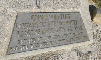
Plaque mounted on the base of a replica cross where Fort St. Georges was located at the mouth of the St. Georges River in South Thomaston, Maine. Tom Seymour photo
On May 18, 1605, Captain George Weymouth (or Waymouth, as some manuscripts phrase it) anchored his ship slightly north of an island off the Maine coast. Weymouth dubbed the island “St. George’s Island,” now known as Monhegan.
Shortly thereafter, Weymouth made for the mainland and discovered a protected harbor at the mouth of a river. Weymouth is alleged to have erected a cross there, claiming the newfound land for England. Over the years, various parties have argued for a number of Maine harbors and rivers as the site of Weymouth’s landing. Among these, strong and conclusive evidence points to the present town of Thomaston and the river the St. Georges River.
In 1977, at the head of the public landing in Thomaston, the Thomaston clergy, along with the bicentennial committee, erected a replica of Weymouth’s cross. Standing there today, next to that cross, the visitor can look across that same harbor and up that same river that Captain Weymouth visited in 1605.
The putting up of crosses was a common procedure during the age of exploration. If done correctly, meaning following all points of protocol, other nations were bound to honor the original claim. Thus, no subsequent explorers for other countries could legally set up their own cross and claim the land, since it was already properly claimed by the country whose cross was raised first.
First Settlers
Although Captain Weymouth discovered and claimed the region in 1605, it wasn’t until 1630 that actual settlement commenced. In June, 1630, five settlers arrived at present-day Thomaston aboard a small sailing vessel, the Lyon. This small group established a trading post, which at the time was called a “truck house,” overlooking the harbor. In time, trade with the local Indians grew brisk.
People seeking a new life in a new land would take up residence in the truck house and remain there, secure from worry, until they could complete their own log houses. Thus the first settlement took hold and life was, while difficult, at least safe. The truck house, although a secure haven for settlers, was not in the true sense, a fort. But it didn’t need to be, since relative harmony existed between the Indians and settlers. Everyone, no matter who, was mostly interested in trade and in their own, personal advancement.
But that changed in 1675, with the commencement of King Phillip’s War. King Phillip was a native leader who orchestrated attacks against the whites. This state of affairs was not confined to Thomaston, but to the entire province of Maine. Within provincial boundaries in 1675 were 13 established settlements, with a population of somewhere between five and six thousand persons.
The truck house was closed in 1675 and was destroyed in 1678, putting an end to the first English attempt at settlement along the St. Georges River at present day Thomaston.
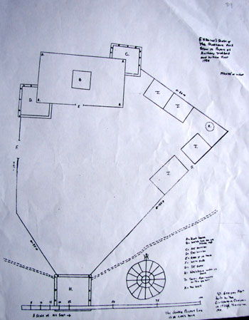
Layout of Fort St. Georges. C = Northeast Garrison; H = Block House; G = Southeast Gate; K = Well; double-dotted line is the river’s edge. Courtesy Thomaston Historical Society. Tom Seymour photo
New Fort
The next attempt at settlement in and around Thomaston began in 1719. This was facilitated by Tarratine chief Madockawando having sold a certain parcel of land encompassing the towns of Warren, Cushing, St. George and Thomaston, to Sir William Phipps, at Pemaquid.
An organization of shareholders, called The Twenty Associates, was created to administer land in this grant. The organization had as its goal, the job of securing families to settle in two newly-formed river towns, one of which was Lincoln, the current town of Thomaston. Immediately, The Twenty Associates began building Fort St. Georges.
Here is a physical description of the fort, taken from Cyrus Eaton’s book “Thomaston, Rockland and South Thomaston, Maine.” Eaton begins: “1719/20 the Twenty Associates erected two strong blockhouses on the eastern edge of St. George’s River with a covered way to the waterside and a large area between them enclosed by palisades. The body of the fort was about 100’ square, constructed of the largest sized trees, hewn about 20’ square and laid solid about sixteen feet high with flankers or projections at the angles, and loopholes for guarding the sides and annoying assailants in the flank. This is described to have been about 200’ from the water and occupied nearly the same situation as the present Knox mansion but nearer the river. Within, around the sides of this main body of the fort were barracks for the soldiers and dwellings for the settlers who now again looked thither for refuge. These were also built of solid timber let into the walls of the fort, twenty feet square, and some of them at least two stores high, each accommodating one or more families. In the center of the fort was a good well, which afforded an ample supply of water for all within. The out-work at the water’s edge and covered way leading to it were also of solid timber with a small wharf in front.”
Indian Attacks
In June 1722, 200 Indians laid siege to the fort, burning the company sloop, killing one man and taking six prisoners. They then attacked the fort, but the defenders kept them at bay. During the course of the siege, the Indians burned a sawmill and two houses and killing a number of cattle. The settlers had nearly used up their store of ammunition during this siege.
Then in spring of 1724, 200–300 Penobscot Indians arrived from upriver in canoes and encamped near the river mouth. The next day they ambushed a hunting party from the fort, killing at least 14 men. Three friendly Indians escaped and managed to return to the fort.
Then on Christmas Day of 1724, 60 Indians attacked the fort, but once again the defenders managed to repel their attackers. The Indians captured two persons and took them as prisoners, but later ransomed one prisoner.
Assorted hostile actions continued off and on and were taken in stride as a fact of life on the Maine frontier. In 1744, Indians participated in another full-fledged attack and once again, were repulsed.
The last notable engagement between people at the fort and the Indians occurred in 1758. Captain John North, an original settler to Thomaston commanded the fort. Under French urgings, a large party of Penobscot, Passamaquoddy and St. John Indians made their way to the fort in order to reduce it to ashes once and for all. But reinforcements, carrying supplies, helped turn the tide in the defender’s favor and the attackers were driven off and quit the battle. In leaving, the Indians killed 60 cattle.
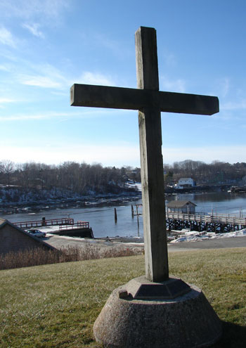
Replica cross installed near former location of Fort St. Georges at the mouth of the St. Georges River in South Thomaston, Maine. Tom Seymour photo
Fort Ruined
During the years after the last attack, things returned to a state of relative peace at the fort and in and around Thomaston. The French and Indian War had ended, and with it the threat of more attacks. It is interesting to note that in 1719, when the fort was built, the St. Georges River was the boundary between French and English territories. By 1762, with hostilities between England and France and her Indian allies ended, the fort began to decay for lack of upkeep. But Captain North remained there, as caretaker. In 1762, the fort was officially decommissioned and the military garrison was discontinued. Kitchen utensils and other material were auctioned off and guns and ammunition were left in care of Captain North.
Perhaps as reward for his long and faithful service, Captain North was granted a license to “sell spirituous liquors.” The following year, the old captain died and was buried at the then half-demolished fort.
In the 1790’s, Revolutionary War hero General Henry Knox inherited the land, part of the “Waldo Patent” and had it surveyed. Knox chose to build his fine mansion, Montpelier, near the site of the fort. Later, while general Knox was away on business, his wife Lucy decided that she was tired of looking at the old fort’s cemetery and so destroyed it, removing all the headstones so she might have a more gentle view.
One of the gravestones that Lucy Knox desecrated belonged to the grave of Captain North. It is said to have wound up in a bucket in someone’s barn, an ignominious end of the memorial to such a gallant and important Thomaston resident. There’s more to the story, though. Captain North’s headstone is said to have had a lead plate inlaid in it, with his name and epitaph. After Lucy Knox’s desecration of the cemetery, someone supposedly pried the lead plate from the stone and melted it down for use as musket balls. Perhaps despite his stone marker being violated, Captain North might have approved of this use of his lead nameplate.
Location Lost
Lucy Knox sold and subdivided much of her Thomaston land. Some of the grand old houses along U.S. Route 1 in Thomaston are relics of this subdivision, among the first of its kind in Maine. Finally, the last direct Knox sibling, a grandson, inherited the land. Townspeople wanted to buy it for historical conservation purposes, but could not enlist enough subscribers and thus were unable to raise the cash. The land, including the site of the long-forgotten Fort St. Georges, was sold to James Creighton, a shipbuilder.
Creighton put in a shipyard and in doing so, totally changed the physical appearance of the land. Today, the location of the fort, the cemetery and other important points are only approximate.
But while the exact site of the fort remains unknown, the memory of what transpired there will never vanish. The old fort and the human interactions that occurred there remain thrilling segments in the long and proud tale of Maine’s history.