
The Bloodless Aroostook War
by Tom Seymour
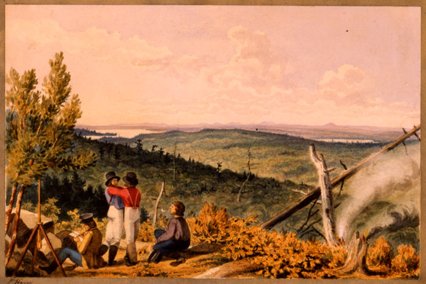
View from Station 212, Talcott survey, 1841. The Talcott survey, headed by Capt. Andrew Talcott, was sent out to map the northern boundary of Maine after hostilities broke out in 1839 between settlers in the Madawaska region around the St. John River. “Artists accompanied the survey and used an apparatus called a camera lucida. Suspended over a sheet of drawing paper, the camera lucida, by means of a prism, projected an exact outline of a particular view onto the paper, which could then be traced. Later, the line drawings were embellished with watercolor.”– from Barry, William and Geraldine Tidd Scott. “Charting a wilderness. Rare drawings of the trackless North Woods resurface after 150 years.” Downeast Magazine, June 1995, pages 59-60. Photo courtesy Maine Historical Society
The formal line of demarcation between the United States and British Canada was first determined by the 1783 Treaty With Great Britain. This was the treaty conducted by Ben Franklin, John Jay, John Adams and Henry Laurens at the conclusion of the Revolutionary War. However, for years after ratification, Britain evidenced dissatisfaction with the boundary lines as set forth in the treaty.
In fact, the United States had an attitude similar to Britain’s regarding the Maine/New Brunswick boundary. Neither side could agree upon the exact location of the boundary line as described in the treaty. So during the term of Maine Governor Lincoln, Maine and Britain agreed to ask the Dutch monarch to act as arbiter and to settle the matter.
In 1831 the King of the Netherlands made his decree, a decree that varied greatly from the 1783 treaty by placing a sizeable portion of Maine (Maine was part of Massachusetts at the time), including the settlements at Madawaska, in Canada rather than Maine. The federal government was disposed toward accepting the new boundary and offered Maine and Massachusetts a payment of land to make up for the loss or money of a value equal to the land to be ceded to Canada.
However, Madawaska’s representative to the legislature disapproved of the proposed new boundaries. And not wishing for her citizens to become Canadian citizens against their wills, Maine agreed with Madawaska and refused to acknowledge the new boundaries. Thus the dispute between Maine and Canada continued, a smoldering fire that would finally heat up at a later date.
Canadian Aggression
Then in 1837, Canadian officials crossed the border and arrested an officer of the State of Maine as he was taking a census of Madawaska residents. The officer was forcibly taken to Fredericton and charged with sedition. All this was according to orders given by the governor of New Brunswick.
The Maine officer was on Maine soil as described in the 1783 treaty when the Canadian authorities accosted him. It was plain that this was a case of the Canadian governor flexing his muscles in an attempt to illegally annex a portion of Maine.
Maine Governor Dunlap acted accordingly. He officially declared that a foreign power had invaded Maine and directed the state militia to prepare themselves for military duty. War seemed imminent.
But the anticipated Canadian invasion fizzled, the officer was paroled and once again, tensions eased for another little while. The situation nationally was a bit different. Some Canadians, particularly in lower Canada, rebelled against British rule. Bands of outlaws composed of Americans and dissatisfied Canadians prowled about, stirring trouble.
A confrontation at Navy Island on the Niagara River resulted in a number of deaths, including those of several American citizens. In this action, the British burned the American steamer Caroline. The two governments openly argued, which occasioned the Americans to expedite construction of the “Military Road,” from Bangor to Madawaska for the purpose of facilitating troop movement to the front.
Armed Confrontation
The next segment of this ever-compounding disagreement involved what today we would call “timber trespass” on the part of New Brunswick woodcutters stealing prime timber from Maine. Penobscot County Sheriff Strickland, along with Land Agent McIntire, formed a 200-man posse and headed directly to Aroostook County, presumably by way of the Military Road, to confront the thieves.
The Canadians, numbering about 300 persons, fortified themselves with arms from the provincial arsenal at Woodstock, New Brunswick. After this, the Maine posse, equipped not only with shoulder arms but also a 6-pound cannon, intimidated the Canadians by virtue of superior firepower. The timber thieves lit out down the Aroostook River. The American posse followed and camped for the night along the Aroostook River, near the mouth of the Little Madawaska River.
Land Agent McIntire, along with four others, left camp and visited a local house for the purpose of meeting with British representative, Land Warden McLaughlin. However, the timber thieves learned of the proposed meeting and perhaps 40 of them captured the Americans and transported them by ox-sled to Woodstock, New Brunswick.
The next morning, Sheriff Strickland learned of the kidnapping and took shelter in a structure known as Number 10. There, the Americans set themselves up as best they could in anticipation of an attack. At that point, seeing his men amply protected, Sheriff Strickland left, riding the 125 miles to Bangor to carry the news of the late events in the Aroostook Region.
Wartime Preparations
At that point, New Brunswick Governor Harvey ordered the arms then in the hands of the timber thieves returned, directing that civil authorities would repel the hostile invasion (the posse from Maine). Governor Harvey then ordered a military draft for immediate service.
On the American side, the government, having been apprised of the situation by Sheriff Strickland, took things seriously and sent 50 volunteers to the border. At the same time, the government in Washington ordered out 1,000 militia men of the Eastern Division. That same evening, Governor Harvey of New Brunswick sent a message to the Americans demanding a withdrawal of the American militia forces, the ones heading toward the disputed territory. Governor Harvey insisted that his government held jurisdiction over the territory and that he would enforce his position through military might.
Hearing of the Canadian governor’s position, the United States legislature appropriated $800,000 to protect American territory. The following day, Maine’s governor ordered a draft of 10,000 men into the militia, there to be held in readiness for military action. It looked as if armed conflict was inevitable.
In March, preparations continued for war with British Canada. The House of Representatives passed a bill supporting Maine’s action toward protecting her own ground. Also, the president was authorized to raise 50,000 volunteers for six months service. The sum of $10,000,000 was appropriated for this purpose. General Winfield Scott arrived in Augusta on March 6. General Scott announced that his mission was to maintain the peace and safety of all the northern and eastern frontiers.
As an example of how Maine towns and cities responded, the quota from the small city of Belfast, Maine, was 30 men. These were selected from the three organized militia companies in that town. These soldiers were sent to Bangor and departed Belfast on February 19, 1839. The selectmen of each town on the way were directed by the legislature to furnish supplies and also transportation to the troops. The state later reimbursed the towns, but only in part, for expenses incurred.
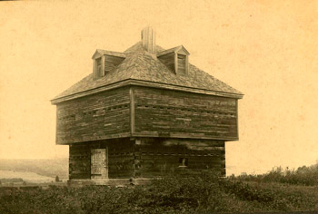
Fort Kent Block House in 1900. The Block House was part of the fortifications built during the Aroostook War. The fort overlooked the St. Johns River and Canada beyond. Photo courtesy Fort Kent Historical Society
Bloodshed Averted
Meanwhile, Sheriff Strickland’s posse had swollen in ranks to 600 persons. The posse, now in the disputed territory, captured McLaughlin, the British warden, as well as a number of ox teams and their drivers. But strangely, there was only minimal opposition from Canadian authorities. The Canadians had departed.
After this, General Scott arrived upon the scene and immediately contacted Governor Harvey in order to conduct negotiations between the New Brunswick governor and Maine’s governor, Governor Fairfield. The Canadian and American negotiators both announced that lacking further instructions from their respective governments, neither would employ military force.
Further negotiations resulted in the withdrawal of American troops, except that a civil posse was left in order to protect Maine timber from further incursions by Canadian woodcutters. Prisoners were freed and several weeks later, troops returned home, happy combatants in what turned out to be a bloodless war.
Boundaries Resolved
Shortly after cessation of hostilities, the Aroostook Region became Aroostook County, the region before that having belonged in parts of both Washington and Penobscot Counties.
But the problem of the boundary between Maine and Canada remained. The two countries continued in discussion and in 1841, William Henry Harrison became the American president. Harrison chose Daniel Webster as his secretary of state. However, President Harrison died a month later and was succeeded by John Tyler.
Although Tyler and Webster had marked political differences, Webster stayed on in his position as secretary of state. Then in spring, 1842, Lord Ashburton arrived from England, fully qualified to enact a new treaty with the purpose of settling the boundary dispute once and for all.
The Maine legislature appointed commissioners to work with Lord Ashburton and Secretary Webster. Then, on July 18, the commissioners formally agreed to a boundary established by Daniel Webster and Lord Ashburton.
In the new agreement, Maine lost a certain amount of land in her far northern reaches. In recompense, the United States received large tracts of land in the vicinity of Lake Superior and Lake Champlain. Also, Maine and Massachusetts (even though Maine had by now declared statehood, Massachusetts at that time remained half owner of Maine’s public lands) each received the sum of $150,000 from the federal government to compensate for the loss of land. Additionally, Maine was given an extra $200,000 as reimbursement for her efforts and expenditures during the Aroostook War.
The United States Senate ratified the Webster-Ashburton Treaty on August 20, 1842, thus firmly, and forever, setting out the permanent boundary between Maine and Canada.