
Eskers, Glaciers and Maine Beaches
by Tom Seymour
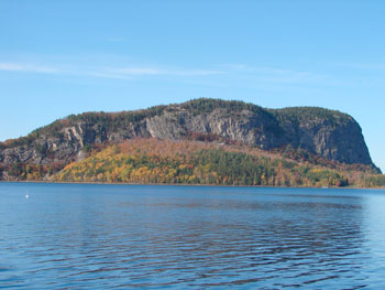
West side of Mount Kineo in the middle of present-day Moosehead Lake. As the glacier slowly swept across rocky Mount Kineo, it tore off huge chunks of flint-like rhyolite, which is now found along the beaches in mid-coast Maine. Tom Seymour photo
Evidence of Maine’s past geological history abounds throughout the state. Much of what we see today, from our mountains to the seashore, reflects massive and powerful natural influences.
Surprisingly, some of the state’s physical features are in an active, rather than static, phase. Many beaches, for instance, are in a constant state of flux thanks to tide and wind action. One such beach, at Sandy Point in the town of Stockton Springs, owes its ongoing facelift to the last glacier.
Let’s back up a bit and examine the glacier and try and piece together its effects upon present-day Maine. Twenty-thousand years ago, at the peak of the ice age, Maine as we know was far in the future. Glaciers thousands of feet thick covered the land. Then, perhaps 12,000 years ago, warming temperatures caused the melting glaciers to retreat.
Interestingly, glaciers melted in an opposite direction from which they flowed. So while the last glacier to cover Maine flowed in a general north-to-south direction, it retreated from south to north. And as it did, it deposited material that it had picked up in its southward progress. Specifically, something like tunnels at the bottom of the ice sheet were filled with gravel and rock, some picked up from the bed of an ancient sea that once extended as far north as Millinocket and other material gathered from mountains that the glacier crossed in its southward trek. One such mountain was Mount Kineo in the middle of present-day Moosehead Lake.
As the glacier slowly swept across Mount Kineo, it treated the mountain’s north-facing side quite gently. But as the ice sheet passed the summit and began its downstream, or southward passage, it tore off huge chunks from the rocky mountain. Mount Kineo is largely composed of a flint-like material called rhyolite. Maine has no native flint and since rhyolite serves well for making stone tools and weapons, early humans quickly began using it for those purposes.
Today, people still discover stone artifacts made of rhyolite around Mount Kineo. But they also find bits of rhyolite along the beaches in mid-coast Maine. We’ll discuss that in a bit.
Glacial Deposits
So as the glacier began melting and retreating, the material in the ice tunnels was left behind. These are called “eskers” and they are ubiquitous throughout much of Maine. Eskers are a tangible reminder of Maine’s traumatic geological past.
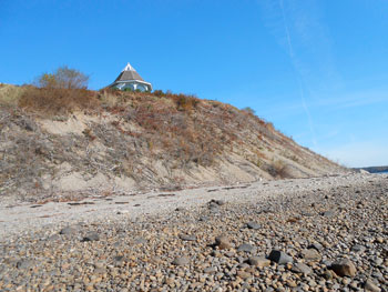
Eskers often extend a great distance. The esker at Sandy Point, mentioned at the beginning of this article, extends approximately 36 miles inland. The end, thought, sits at the western edge of the mouth of the Penobscot River. From the land, the existence of the esker is pretty much hidden but from the shore, its existence is quite obvious.
Standing atop the esker at its very end and looking down, the viewer sees nothing but a precipice at the edge of the sea. But looking up, the view changes dramatically. A steep bank, made of sand and gravel, looks as if it may begin to crumble at any moment. And in fact, it is slowly crumbling, as wind and wave action erodes the esker. This in turn has served to create, and continues to create, a brand-new beach.
One Sandy Point resident recalls that 40 years ago, it was possible to wade out through relatively shallow water for a considerable distance. Now, thanks to a changing landscape, deeper water comes quite close to the shore. The beach, as she knew it as a child, appears very much different.
The composition of the esker deserves mention. It contains Sand, Kineo rhyolite bits and larger pieces, stone cobbles, gravel and a number of marine fossils. Deposits of a similar nature abound in Maine and form the basis for a thriving gravel extraction industry in the form of gravel pits. Thus, the gravel we order for our driveways and dirt roads was initially carried to its present location by a glacier and left intact as the glacier retreated. Such pits make gravel extraction easy, since they permit of easy access. Some pits, being on top of aquifers, eventually fill up with water and become crystal-clear ponds.
Some commenters wanted the federal government to cover the entire cost of observer coverage. But NEFMC supported a split coverage, due to NMFS’ concerns about the government’s ability to cover the entire cost. Tom Seymour photo
Developing Beaches
While the Sandy Point esker is not the only such one in Maine, it serves as an exemplar of how the forces of nature serve to construct beaches. The Sandy Point esker, on the west side, has but a narrow beach because it is protected from tides and river currents. But the east side has spread out considerably and from its very tip just below the high end point of the esker all the way up do the present park area.
Near the tip of the esker, a long cobble field catches the eye. These are stones, washed by melting ice water while still at the bottom of the glacier, and spread out in a long, even sheet. Further up, near the state park, fine gravel and even pure sand becomes the main ingredient.
While the very end of the Sandy Point esker is in private hands (Hershey Retreat, a grand, Victorian inn, is now a superbly-landscaped location for weddings and conferences), the high end, or tip of the esker is plainly visible from Fort Point, just across the water.
As suggested earlier, the Penobscot River has a hand in eroding the esker’s eastern side and consequently, material from the esker has moved a significant distance upstream on the same side.
As the process of erosion continues, the esker will continue to yield its treasures to the elements. And unless another ice age intervenes, the process should continue indefinitely.
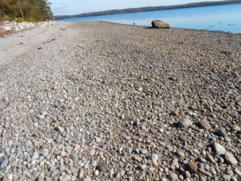
Lines of cobblestone eroded from the esker, spread along the Sandy Point Beach. Larger sizes of these rounded and flattened stones were used to pave streets in New England towns in the early 1700’s. Tom Seymour Photo
Maine Eskers
Other eskers throughout Maine are of interest too, and Hancock and Washington Counties have their share of them. One well-known esker, and one that most everyone who has ever driven on Route 9, “The Airline” has probably seen, is called The Whalesback, located 5 miles east of Amherst. A 75-foot high, 2 - mile long ridge, parallels the Middle Branch of Union River. It commands a panoramic view of the vast glacial plain through which the river flows.
The Chesterville Esker, which reaches up to 90 feet high, stretches between Horseshoe Pond and Norcross Pond. The Ridge Road follows the esker.
The Bingham Esker, which also reaches up to 90 feet high, sits alongside the Kennebec River. This esker, reachable by road, has especially steep sides and in places, would give an acrophobe shivers.
Even far northern Maine has its eskers. The Littleton Esker in Littleton, Aroostook County, closely parallels Route 1. The esker averages about 60 feet high.
For detailed information on Maine eskers, consult The Glacial Gravels of Maine and Their Associated Deposits (a monograph of the USGS, Volume 34), George H. Stone. Amazon sells new and used copies of this book and local booksellers can order it if they don’t have it in stock. The DeLorme Gazetteer for Maine lists Unique Natural Features on page 13.
The next time you drive down a Maine road and wonder what made the steep ridge that the road follows, just remember that it might be an esker, formed by the retreating glacier.