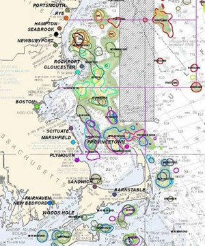
Unlike their portside counterparts, at-sea fishing communities have been undocumented and largely unknown. Researcher Kevin St. Martin, from Rutgers University recently teamed up with the NMFS Northeast Fisheries Science Center and researcher Madeleine Hall-Arbor, MIT Sea Grant, to develop a mapping tool that links port communities in New England to fisheries resource areas. The project, which was funded in part by the Northeast Consortium (NEC) developed a tool, dubbed the Atlas Project. The Atlas Project uses Geographic Information Systems (GIS) to produce maps based on anecdotal and scientific evidence of areas and resources in the Gulf of Maine that fishing communities depend upon. This was new territory for looking at spatial distribution of fishing activity. “This project is fundamentally different, we are not mapping fishing effort using landings data but mapping at-sea fishing communities and how those communities have changed over time,” St. Martin explained. Filling in the cartographic gaps will help to shed light on the human aspect of the marine ecosystems and may ultimately influence future fisheries management plans. Mapping Fishing Communities Researchers used vessel log book data collected by NMFS since 1994 to link fishing trip locations with the home port associated with that vessel. Forty-three maps were created using digital mapping software (GIS) depicting community utilization of fishing areas in the Gulf of Maine. Each community has information based on the number of vessels, average crew size, average catch, along with other statistics. Fifty nine fishermen, mostly captains, were interviewed at five different ports within the Gulf of Maine, ranging from Chatham, MA to Port Clyde, ME. “Fishermen were given the opportunity to review the community maps and make changes based on their recollection of fishing areas over that time,” said St. Martin. Key to this project was having fishermen tell their stories. These narratives were included to add information about their local environmental knowledge and fishing experiences to the maps. According to the report, which is available on the NEC website (www. northeastconsortium. org), fishermen also viewed the Atlas Project as a way to convey their spatial, territorial and management concerns for the different regions where they fished.
The project was designed to document community processes, rather than geographic boundaries on the water. At-sea communities are likely to change based on new management regulations, environmental conditions and a host of other factors. Without a map, any displacements of traditional fishing territories may be difficult to trace or document. The lack of a map that depicts fishermen’s use of at-sea locations could also cause difficulties when trying to assess a location for offshore development such as wind farms. Potential Benefits The benefits extend to fisheries managers and fishermen alike. Managers can use these maps to evaluate how proposed area-based regulations might benefit or displace at-sea fishing communities. Similarly, fishermen could use the Atlas Project maps as justification for their concerns regarding proposed management changes and the impacts on the community. Also, the tool would allow scientists to better discriminate broad categories of fishing such as trawling, hook or gill-net fisheries by location, community, boat size, and utilization history. According to the NEC report, the Mid-Coast Fishermen’s Association in Maine attributed their formation to the Atlas Project. What’s Next Now that the atlas-based audit of fishing communities has been completed, the information needs to be made available to fishermen, managers, scientists or any interested stakeholder. To address this need, St. Martin, joined by additional Rutgers and NE Fisheries Science Center colleagues, have developed the “Communities-At-Sea Mapper.” This tool uniquely maps the locations of at-sea fishing communities providing an online interface which allows users to browse data visually. Instead of solely defining fishing areas by catch numbers, the mapper will put people (fishermen) into the marine environment itself as resource users described by their port, fishing locations, experience and knowledge. Users can explore how fishing areas have changed over time and display regional narratives from industry interviews linked to the specific region. In other words, not only can at-sea fishing community maps be visualized but you can actually gain personal perspectives from the members from a specific fishing community. “The tool will inform groups that seek to solicit community-level participation in fisheries management and account for community impacts,” St. Martin said. He also noted that “GIS maps of community presence are essential to any ecosystems-based analysis that seeks to meaningfully incorporate communities of resource users, their practices, environmental histories, and their local ecological knowledge.” He goes on to say that “Knowing which communities of fishermen use specific habitats is fundamental to understanding the human dimensions of ecosystems and ecosystem change.” For more information about the tool and St. Martin’s research, see http://geography.rutgers.edu/people/faculty/stmartin/research.html. Authors: Ken La Valley PhD, Assistant Extension Professor of Biological Sciences Extension Specialist, Fisheries and Aquaculture NH Sea Grant/UNH Cooperative Extension. ken.lavalley@unh.edu Rebecca Zeiber, Science Writer, N.H. Sea Grant, Kingman Farm, University of New Hampshire, Durham, N.H. 03824 |