
Kineo Flint
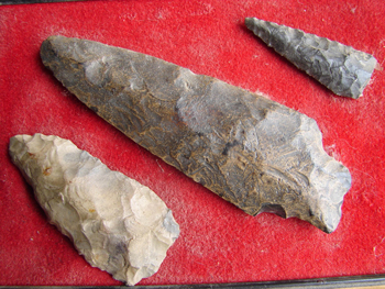
Flint and flint products were traded among native Americans in the northeast. Arrow and spearheads were common.Making good ones was an acquired skill not everyone had it. The spearhead, center is approximately 5" long, the white chert arrowhead, lower left, is 2 3⁄4" long, and the arrowhead, right, is 2" long. ©Photo by Tom Seymour
A hike along the rocky coast of Maine in summer provides respite from the heat and humidity plaguing people just a few miles inland. A smoky haze hangs over the water, blurring images of distant islands. A bell buoy clangs, ever so softly, rocked by gentle swells. And there, along the path, lies a shiny, gray stone, unlike all the others.
Closer inspection discloses tiny, water droplets, the result of condensation, on the smooth surfaces of the walnut-sized stone. Surfaces? Yes, the stone has facets. These lack sharp edges, an indication that the thing was once subject to wave action. Someone, at some time, had held this very stone in hand and chipped away at it. Who did that, and when?
Similarly-shaped stones of varying sizes crop up not only on the immediate shoreline, but also on and along gravel roads and old-time farm lanes. In fact, those searching for these curiously-fashioned stones would do well to concentrate upon such roads and paths, rather than upon the actual shore.
The stones, a form of flint known as Kineo rhyolite, were hauled in with the gravel initially used to build the old-time roads. Frost action occasionally brings these stones to the surface, where they are easily spotted. But the question remains, how did they arrive on the coast and in coastal gravel quarries?
Mt. Kineo
Mt. Kineo, a 1,789-foot monolith, rises up from the middle of Moosehead Lake in northern Maine. Its barren cliffs make Kineo the most widely-recognized landmark in all of the north country. But something else besides its unique location and appearance sets Kineo aside from other Maine mountains. It is the largest known mass of rhyolite in the entire country. And rhyolite was once the source of weapons and tools for the early, indigenous people of Maine.
In addition to its use by early paleoindian people (the first to inhabit Maine and the Canadian Maritimes after the last glacier melted) “Kineo flint” was valued by various tribes of later years. In fact, implements made of this same flint have appeared all over New England and even points south, clear evidence of its value to native Americans.
Before European colonization, an annual trek to Mt. Kineo for the purpose of collecting rhyolite was in important aspect of Maine life. But a certain amount of rhyolite occurred along the shore and this, too, became a source of tools and weapons.
According to The Audubon Society Field Guide to North American Rocks and Minerals, published by Alfred A. Knopf, Inc., 1978, rhyolite is formed by the rapid cooling of magma that erupts at the earth’s surface or enters into the crust at shallow depths. This indicates volcanic origin and in fact, Mt. Kineo, along with several other Maine mountains, is an ancient, extinct volcano.
The question remains of how flint from Moosehead Lake arrived at ocean’s edge. The last glacier carried pieces of rhyolite from Kineo and deposited it along the shore. Some of these were fairly sizable, but most were rather small, the result of grinding under tremendous pressure exerted by the mountain of ice.
The area from Lincolnville to Stockton on Penobscot Bay, Maine, has a considerable amount of remaining specimens of both worked (chipped or otherwise fashioned by human hands) and un-worked rhyolite. Also, Jean Blakemore’s book, We Walk On Jewels, published by Courier of Maine Books, 1976, mentions rhyolite formations in Castine Township as well as within the Deer Isle Quadrangle. This, however, appears to be of lesser quality than Kineo rhyolite and probably not as valuable for tool making.
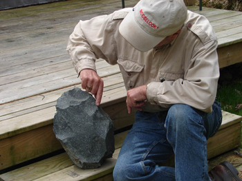
Tom Seymour examining the sharp edge of a chunk of flint. Smaller pieces were broken out of larger chunks and worked into sharpened tools. ©Photo by Tom Seymour
Implement Types
Besides the rough specimens so commonly seen, sharp-eyed observers sometimes encounter whole tools and projectile points. Interestingly, these are unfluted, meaning that they lack the groove at the bottom, meant to accommodate a shaft. Further, these implements, when viewed from a face-on position, resemble a squat, three-sided, triangle or pyramid, widest at the bottom, with two, equal sides.
Interestingly, such a design is identical to tools and points made of chert, found in locations far inland. Some examples of this hail from a primitive quarry site at Munsungan Lake in Piscataquis County, Maine. This similarity of design would indicate that the same people who fashioned the implements we find along the shores of Penobscot Bay also created the specimens from Munsungan.
While most implements we find exhibit a certain roughness, many of those found in the Lincolnville area are of an extremely smooth quality. This raises the question of whether or not this smoothness results from wave action, or was it purposeful, the work of hours and hours of shaping and smoothing? If the former were true, then why do specimens found in other Penobscot Bay locations not show a similar degree of smoothness? The truth remains unclear.
One particularly enigmatic specimen, found well away from shore while harvesting surf clams during a low-drain tide, looks for all the world like a human heart. The best guess regarding this piece is that it was a talisman, designed for either protection or perhaps, for ritualistic use. We have no way of knowing for sure.
Stone-Age Marvel
The stone-age person who discovered how rock fractures in a predictable way when pressure is applied, or when struck, probably didn’t realize the importance of this knowledge to the human race. To make stone tools from flint, the worker began with a large section of stone and began to shape it by striking with another stone. The resulting chips, often, were sharp enough to use for scraping hides, meat cutting or cleaning fish.
To further shape a particularly worthy chip, the worker applied pressure with a tool, probably made of antler, to remove smaller portions, working the rough stone into the three-sided artifact that modern humans would discover so many years into the future.
Some of the larger portions of flint yielded many tools. These were of particular value, and we now know them as “cores.” Once some chips are removed from a core, the rest can be removed with fairly uniform results. Some of these cores remain today for us to view. If a core lies far enough away from the high-tide line, its edges often remain razor-sharp, even dangerous to the errant hand or finger.
Also, the area around a core will likely be rich in chips, as well as implements that were broken during the tool-making process and immediately discarded.
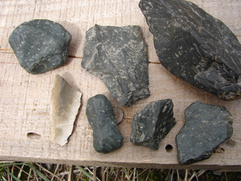
Rhyolite artifacts from Penobscot Bay. Lower left is a piece of chert from Munsungan Lake. ©Photo by Tom Seymour
Flint Hunting
To pick up and hold one of these tools, even a sharp-edged chip, is to establish a direct link between Maine’s first inhabitants and present-day humans. Just possibly, the last person to hold the three-sided projectile that we pick up today lived nearly 10,000 years ago.
So how difficult is it to locate these ancient links to the past? Actually, it’s quite easy. All it requires is the ability to instantly recognize rhyolite, to distinguish it from other, vaguely similar rocks and stones.
For the most part, rhyolite occurs in varying shades of gray, with little white specks, or intrusions. The first point to remember when noting a grayish rock, is to see if these specks are present. Then, pick up the stone and feel it. The waxy property can be felt as well as seen, particularly on specimens found along the shore. Chips and tools found away from the shore usually do not exhibit this waxy property.
Next, try to recognize the difference between human-made faceting and naturally-occurring facets. Sure, rocks and stones often break and when that happens, they fracture. But these are obvious and it takes a real stretch of the imagination to consider them purposefully formed.
In the case of specimens found along the immediate shore and also, those found along gravel roads and lanes, the facets are more than likely to have smooth edges, the result of thousands of years of washing by ocean waves. All the same, even these are easily recognizable as something out-of-the-ordinary.
An important feature to look for, of course, is the three-sided aspect mentioned earlier. Any three-sided, gray stone with white flecks bears further scrutiny. If it meets the criteria for rhyolite, it probably ranks as a genuine artifact.
Some pieces, though, while certainly shaped by human hands, are merely examples of a work-in-progress that was discarded for whatever reason. These come in a number of shapes, but show indications of faceting.
When walking the seashore, don’t look for Kineo rhyolite among wet stones. Instead, concentrate upon either that area just above the high-tide line or, better yet, wait for the sun to dry the beach as the tide recedes. Then, given its waxy, wet appearance, rhyolite stands out in sharp contrast to other beach stones.
Who knows how many hundreds, perhaps thousands, of others have passed by that particular bit of history, without realizing what it was? Kineo rhyolite and the people who used it to eke out their living from post-glacial New England and Maritime Canada are both unique natural treasures.