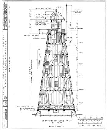
Through telescopes in these towers, distant ships could be seen approaching a harbor. Tower operators raised signal flags that identified the ship and its distance. This was valuable information for merchants in the days before radio or any other electronics. Ships might be gone months or years with little or no contact with the owners. Signal towers gave them time to organize the effort to reserve wharfage, gather men to unload their ship, prepare for distribution, and in some cases know if they would be first to market. Galileo, known today as an astronomer, was also a telescope builder. Venetian merchants prized Galileo’s powerful telescopes for the edge it gave them in the market. Portland was settled on the Neck, a section of land bordered on one side by Back Cove and on the other southeast facing side by the Fore River and Casco Bay. The Neck has high ground on the southwest end, altitude drops toward the middle, and rises at the northeast end, known as Munjoy Hill after its owner in the 1660’s. At the turn of the nineteenth century most of Portland’s 4,000 people and its businesses were on the Neck, close to the sea. Lumber, fish, and ships were the principal commerce. The buildings, mostly rebuilt in brick after the British fire bombed the wooden town in 1775, destroying more than 440 buildings, were clustered at the waterfront. While Portland had deep water, easy access, and a protected harbor, merchants could not see their ships approaching. Arrivals were difficult to predict. Weather, storm damage, and foreign port authorities were just a few of the causes for delayed return from a long trip of many months. Moody proposed to Portland merchants that he build a tower and finance it by selling shares ($50 each) to subscribers. Others could pay per report for information on an incoming ship. With land on Munjoy Hill deeded to him by his father Enoch, Lemuel’s location was well situated for the tower. Most of the trees at that end of the neck had been cut down and the area was grazing pasture for the town. The tower would be one of the few buildings that far from the port. In fact, it stood virtually alone near the top of the hill. Moody produced the drawings and supervised the construction. He ordered eight 65-foot long timbers, 14 inches square at the base and 10 inches at the top. They were used to make the eight corners of the octagon. There were six stories, capped by the “lantern,” an observation room, with windows all around for a 360 degree view. Above this was a dome, with signal poles around its perimeter on which signal flags were flown. Built on a stone foundation, the tower was anchored at the base with heavy 14-inch square timbers, which were covered by 122 tons of stone rubble for ballast. He was familiar with the solid construction of sailing ships and this made its way into the design. The lantern at the top floor with windows all around had the degrees of the compass painted on the ceiling. Moody ordered a P & J Dollond Achromatic Refracting telescope from the London Company. This state of the art telescope was mounted and suspended from the ceiling of the lantern. The 66-inch long telescope, had a three and a half-inch lens and a magnification ratio of 65 to1 that enabled him to identify ships 18 miles away. The signalizing tower was a wonder of the area. No other building was as tall. From its perch on the hill it provided a spectacular view of the harbor and town, and still does. It was a point of interest to visitors. One of them was Captain William Burrowes, the 23-year-old captain of the U.S. naval vessel Enterprise in 1813. He hiked to the tower from the port and may have been curious about whether he could spot the British warship the Boxer. It was during the War of 1812 and the Boxer had been harassing merchant ships in the Gulf of Maine. Two days later Burrowes would encounter the Boxer off Pemiquid Point. Smoke from the battle that ensued may have been visible from the observatory. The 25-year-old British captain Samuel Blyth was killed in the opening rounds, and Burrowes died of his wounds in the last minutes of the battle. The residents of Portland gathered to form a funeral procession. The bodies of both captains were carried through the streets of the town, then up Munjoy Hill and buried side by side in the old Eastern Cemetery, a few yards below the observatory. Moody used common signals, but developed some signals of his own. These changed over the years, but his objective was to report what he saw to his clients on the wharves about a mile away. This was done with various flags and pennants hung from the Observatory’s three flagpoles in a systematic way. There were flags for specific ships, as well as others that indicated goings on beyond the view at the waterfront. Below is a sample of the information, other than a ship’s name and distance from port, relayed to merchants. From a book of sketches by Moody’s son Enoch dated 1833, 24 flags and a system for flying each is illustrated. Lemuel added more details over the years, below are samples of the basic system. • a pennant at half staff indicates a slop on shore if yellow, a schooner on shore if blue. • two pennants, both red, indicates a wreck. • individual ships had a specific flag. Moody also recorded detailed weather information, seventy years before the National Weather Service was established in 1876. From the vantage point in the tower, weather could be seen developing from all directions. Moody’s other accomplishments include being Portland’s first weatherman. He was a systematic and experienced weather observer who kept detailed records of daily conditions at Portland from 1816 to 1845. His son Enoch, who took over management after his father’s death, kept weather records until 1852. Lemuel’s long experience in a life at sea taught him to read nature’s signs. He had a unique vantage point atop his tower high on Munjoy Hill to observe weather formations. In 1825 Moody drew a chart of Casco Bay. According to a 1992 study Casco Bay has 723 islands and reefs. Before Moody’s “Chart of Casco Bay” navigation was hit or miss with the emphasis on the former. Very accurate charts were not available until the middle of the 20th century. The Observatory was used continuously from 1807 to 1923. The invention of the two-way radio by Marconi in the early 1900’s made the towers obsolete by 1923. The Portland Observatory sat idle until 1937 when Edward York, the Great Grandson of Lemuel Moody, gave it to the City of Portland. In 1939 it was restored by the Works Progress Administration. It remained open until 1994. The tower had become a place where neighborhood children played. The discovery in 1994 of powder-post beetles in the frame of the tower meant it would be torn down if not rebuilt. Fund-raisers raised 1.2 million dollars, a major restoration was completed, and the tower reopened in 2000. The original purpose of the Observatory has long been obsolete, but the view of the bay and Portland remains great.
|